
GPS Fleet Tracking & Telematics
What Is Geofencing? How It Works in Fleet Tracking
Geofencing is a virtual boundary around a location that alerts you when a tracked vehicle enters or leaves it. How fleets use it, its limits, zone tips.

What Is Geofencing in Fleet Tracking?
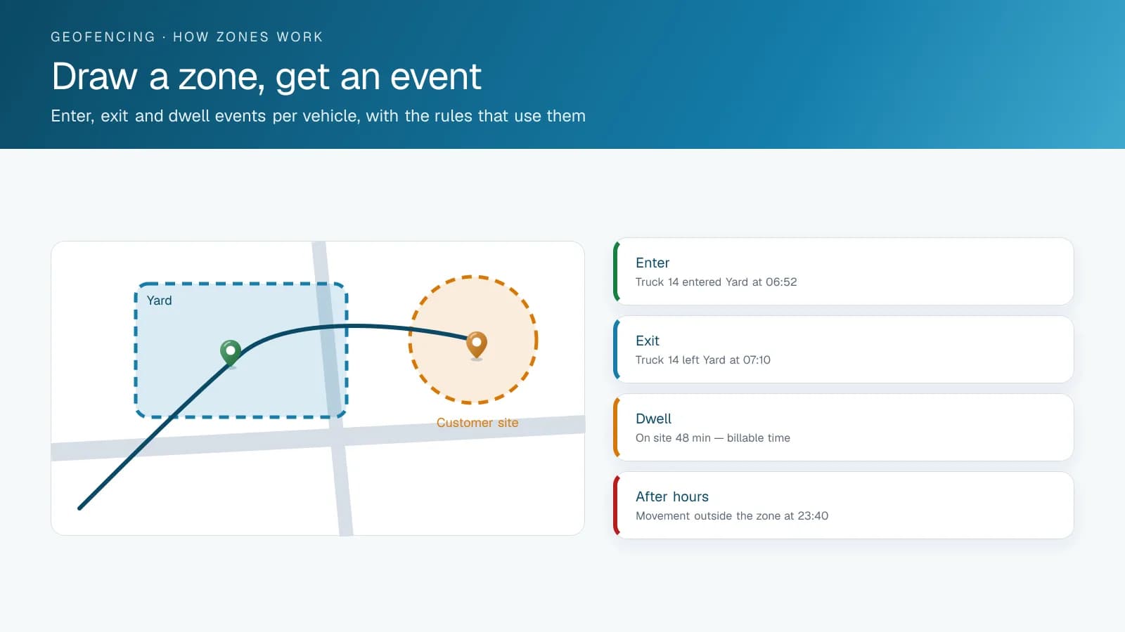
Geofencing is a virtual boundary drawn around a real-world location, such as a job site, a customer address, a yard or a radius around a city, using GPS coordinates instead of a physical fence. Once you set that boundary in a fleet tracking platform, the system checks each tracked vehicle's live GPS position against it and fires a defined action, usually an alert, whenever a vehicle crosses in or out.
The boundary can be a simple radius around a point or a custom polygon that follows a property line or job site perimeter. Which one you pick depends on how closely the zone needs to match the physical space it stands for.
What Is Geofencing Used For in a Fleet?
Arrival and departure tracking is the most common use. A geofence around a customer site or job location logs when a vehicle entered and left, which gives you time-on-site data for billing or service-level reports without a driver logging anything by hand. After-hours and unauthorized-movement alerts come second: a geofence around a yard or depot flags any vehicle that moves outside expected hours, which helps deter theft and speeds up recovery if something is taken.
Fleets also use geofences defensively, to flag a vehicle that strays outside its assigned route or service area. On the admin side, a geofence can tag trips that start or end in a specific zone for reporting or IFTA jurisdiction purposes, since it can mark a state or provincial line as easily as a customer address.
Is Fleet Geofencing the Same as Geofence Marketing?
No. Both draw a virtual boundary on a map, but fleet geofencing checks the position of your own vehicles, reported by a GPS device installed in each one, while geofence marketing uses the location services on people's phones to show them ads or offers when they walk into an area. Search results for "geofencing" mix the two because the word covers both.
The difference shows in what comes out. A fleet geofence produces arrival and departure times, after-hours alerts and time-on-site reports in your fleet platform, tied to a vehicle and a driver. A marketing geofence produces ad impressions and store visits, tied to anonymous phones. If you are shopping for geofencing to run a fleet, look for it as a feature of GPS fleet tracking, and ask how the zones are drawn, which events they can trigger and who receives the alerts. The legal side differs as well: a fleet geofence follows employees at work, which brings in the workplace monitoring rules covered next.
Do You Have to Tell Drivers About Geofencing?
In Ontario and Quebec, the law expects you to. Ontario's Employment Standards Act requires an employer with 25 or more employees on January 1 to have a written policy on electronic monitoring in place before March 1 of that year, and the province's own example of electronic monitoring is GPS tracking of a delivery vehicle. The policy says whether you monitor, how and in what circumstances, what you use the information for, and the dates it was prepared and changed.
Quebec's Act respecting the protection of personal information in the private sector goes further on notice. Section 8.1 requires anyone who collects personal information with technology that can identify, locate or profile a person to inform that person first of the technology and of how its locating or profiling functions are activated. The law's definition of profiling names the analysis of work performance and behaviour.
Other provinces and US states have their own rules, so check them before rollout. A written policy that names the geofences, the alerts they send and who reads the reports is a sound baseline wherever you operate, and it gives drivers a straight answer before they have to ask.
What Are the Limits of Geofencing?
Geofencing depends on GPS signal and reporting frequency, so it flags a boundary crossing once the platform detects it, a little after the fact instead of to the second. A vehicle moving fast through a very narrow zone can sometimes cross in and out between two position updates. The zone is also only as accurate as the boundary you draw. A radius set too wide around a dense urban job site can trigger a false arrival alert while the truck is still a block away.
For arrival and departure logging and boundary alerts, the job it was built for, geofencing is reliable. Set expectations accordingly, though, and don't treat it as a substitute for live, second-by-second vehicle tracking.
How Do You Draw Geofence Zones That Work?
Most geofence problems are drawing problems. A zone drawn tight to a building's footprint misses trucks parked in the lot, and one drawn over the whole block catches the coffee shop next door. These are the rules High Point GPS uses when it sets up a fleet. Draw customer zones around the whole property, including the lot and the approach, instead of around the building. Give yard zones a margin so a truck idling at the gate counts as home. Keep billing zones separate from alert zones, because a billing zone should be generous and an after-hours zone should be strict. Name zones the way your office talks about them, so reports show customer names instead of coordinates. You can import zones in bulk from a customer list with addresses, and expect to redraw the ones that fire wrong in the first month, which is normal.
Frequently asked questions
What is geofencing in fleet tracking?
Geofencing is a virtual boundary drawn around a real-world location using GPS coordinates. A fleet tracking platform compares each vehicle's live position against that boundary and triggers an alert or logs an event whenever a vehicle enters or exits it, which gives you arrival, departure and time-on-site data without manual logging.
What is geofencing commonly used for?
Fleets use geofencing for automatic arrival and departure logging at customer sites and job locations, and for after-hours or unauthorized-movement alerts around a yard. It also flags vehicles that leave an assigned route or service area, and tags trips by jurisdiction for reporting, including IFTA, since a zone can follow a state or provincial line.
Is geofencing accurate in real time?
Geofencing is accurate to the vehicle's GPS reporting frequency, so it flags a crossing shortly after it happens instead of at the exact second. Accuracy also depends on how well the zone was drawn: a radius set too wide around a dense job site can trigger an arrival alert before the truck gets there.
How many geofences can a fleet create?
Platforms differ, so ask your provider whether any limit applies to your account. On the High Point GPS platform, zones can be imported in bulk from a file, and fleets usually group them by type, such as yards, customer sites and no-go areas, so a single rule can apply to a whole group at once.
Can a geofence trigger an alert only after hours?
Yes. A rule can combine a zone with a time window, so a vehicle leaving the yard at night raises an alert while the same movement at 7 a.m. does not. Keep after-hours zones strict and separate from billing zones, which work better when they are drawn generously.
Do Ontario employers have to disclose GPS tracking and geofencing?
Ontario's Employment Standards Act treats GPS tracking of a work vehicle as electronic monitoring. An employer with 25 or more employees on January 1 must have a written policy before March 1 of that year stating whether it monitors, how and when, what the information is used for, and the dates the policy was prepared and changed.
Is geofencing in fleet tracking the same as geofencing in marketing?
No. Fleet geofencing compares the GPS position of your own vehicles against zones you draw and produces arrival times, alerts and time-on-site reports. Marketing geofencing uses the location services on people's phones to serve ads when they enter an area. The boundary idea is the same; the data, the purpose and the buyer are different.
Sources
Related solutions & products
Related terms
Continue reading
- GPS Fleet Tracking & Management Software overview →
- Benefits of GPS Fleet Tracking: What Changes When You Can See Your Fleet →
- GPS Tracker for Work Trucks and Company Vehicles: A Small Business Guide →
- Company Vehicle GPS Tracking Policy: Can My Employer Track Me? →
- What Is Telematics? Fleet Telematics and GPS Data Explained →
- More in GPS Fleet Tracking & Telematics →
Get a free quote
- Over 500 fleets
- Since 2013
- 4.9 on Google (19 reviews)
What are you looking for?
Prefer to talk?Call 1-800-613-6323[email protected]