
Industry
GPS Fleet Tracking for Fire & Emergency Services
GPS tracking for fire departments that logs lights and siren, measures response times, judges code-3 driving fairly and services apparatus on hours.
Updated September 19, 2026
High Point GPS gives fire departments GPS tracking on every engine, ladder, tanker and rescue, with lights-and-siren status recorded on each trip so response times and emergency driving are measured fairly. The chief and the dispatcher see the whole fleet on one live map. A department's fleet is small, expensive and judged by minutes, and the same GPS tracking device that reports position also reads the vehicle's own circuits through its auxiliary inputs. Wire the light bar and the siren to those inputs and the platform knows, second by second, when a truck is responding under lights and siren and when it is driving normally. With that status in the record, response times run from the moment the truck leaves the bay to the moment it arrives on scene. Speeding and hard braking during a code-3 response are recorded but not counted against the driver, and alerts are held to the standard for emergency driving instead of the one for a delivery van. Maintenance runs on engine hours and pump hours, DVIR replaces the clipboard for the daily apparatus check, and geofences around every station and mutual-aid boundary produce the records a department needs for NFPA reporting, fire insurance grading (ISO in the US, the Fire Underwriters Survey in Canada) and the council meeting.
Common challenges
- Response times rebuilt from radio logs and memory instead of measured from wheels rolling to on scene
- Driver-behaviour reports that treat a code-3 run like a speeding violation, so crews ignore the data
- No record of when the lights and siren were on during a response or a return
- Apparatus maintenance scheduled by the calendar while pumps and engines wear by the hour
- Daily apparatus checks on paper, with defects that reach the mechanic only after the truck fails
- Mutual-aid runs, training and public events that leave no record for cost recovery or reporting
How High Point GPS helps
- Live location of every apparatus on one map, with station geofences that time-stamp leaving the bay and returning
- Lights-and-siren detection through the GPS tracking device's auxiliary inputs, logged with each trip as its own status
- Response-time reports from bay departure to on-scene arrival, per incident and per apparatus
- Exception rules that record code-3 driving events without counting them against the driver's score
- Maintenance reminders on engine hours, pump hours and PTO time, with fault codes read from the engine
- Electronic DVIR for the daily apparatus check, with defects sent to the mechanic the same morning
- Trip history and geofence reports for mutual aid, training, hydrant runs and public events
- Dispatch integration through the open API, so the CAD sees the same live position
How does lights-and-siren tracking work on fire apparatus?
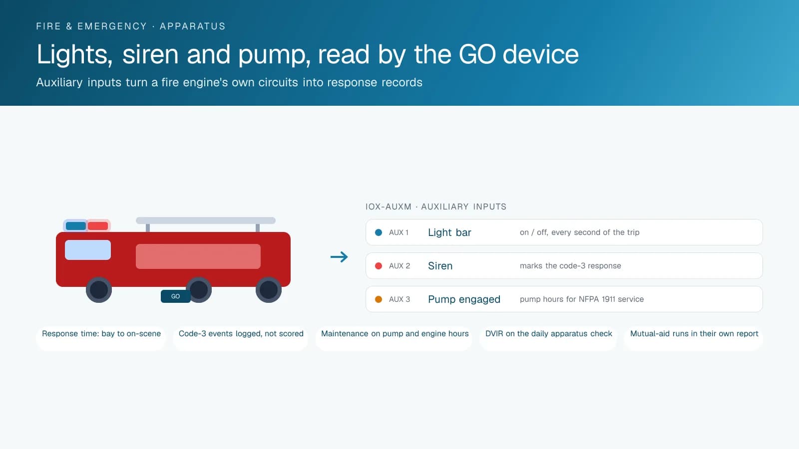
A technician wires the emergency light bar and the siren to auxiliary inputs on the GPS tracking device, and every trip record then shows whether the lights and the siren were on at each point along the route. The device itself connects at the apparatus's diagnostic port through a T-harness for position, speed and engine data. An IOX-AUXM expansion module adds eight auxiliary inputs, each reading whether a vehicle circuit is on or off. A third input on the pump engagement or PTO circuit tells the platform when the truck was pumping on scene.
That status separates emergency driving from everyday driving in the data. A speeding event, a hard brake or a fast corner with the lights on is recorded as part of the response, and the driver's score leaves it out. The same event on the way back from the call, or on a hydrant run, counts the way it would in any fleet. High Point GPS configures the rules and the reports during setup, so the department sees response driving and routine driving in separate columns from day one.
Measuring Response Time Instead of Estimating It
A geofence around each station marks the moment the apparatus leaves the bay. The lights-on status marks when it went into response mode. The address of the call, entered from dispatch or matched from the CAD through the API, marks the arrival on scene. Between those points, the platform holds the turnout time, the travel time and the total response time for each apparatus on each incident, with the route it took. Chiefs use those figures for reporting under NFPA 1750 (which replaced NFPA 1710 and 1720), for the annual report to council and for fire insurance grading (ISO's Public Protection Classification in the US, Fire Underwriters Survey grades in Canada), without a captain reconstructing the timeline from the radio log afterwards.
The same records answer the questions that come up after a difficult call. Which apparatus went, which route it took, how long it sat at a rail crossing, when it cleared. Trip replay shows the response on a map with the lights status alongside, which settles disputes with a resident or a neighbouring department in minutes rather than weeks.
Maintaining Apparatus on Hours, Not Miles
A fire engine may drive a few thousand kilometres a year and still work its pump and engine hard, idling at scenes and pumping for hours at a fire. Mileage-based maintenance misses that wear. The GPS tracking device reads engine hours and, through the PTO or pump input, pump hours, so the High Point GPS platform schedules the pump test, oil changes and other service intervals on engine and pump hours, alongside the inspection and testing schedule in NFPA 1910 (which replaced NFPA 1911). Engine fault codes reach the fleet mechanic as they are logged, which matters most on the apparatus that rarely leaves the bay.
Electronic DVIR replaces the paper checklist for the daily and weekly apparatus check. The firefighter on duty runs the inspection in the driver app, a defect is routed to maintenance with a time stamp, and the repair and sign-off are recorded before the truck goes back in service. That record is what an auditor or an investigator asks for after an incident, and it is complete without anyone chasing paper.
Records for Mutual Aid, Training and the Public
Not every run is a call. Departments log training drives, hydrant flushing, public-education visits and mutual-aid responses into neighbouring districts, each of which has a cost and, in the case of mutual aid, often a reimbursement. Geofences around the district boundary, the training ground and neighbouring stations put those trips in their own reports, so the finance office has the distance, the hours and the apparatus for each one without a separate log.
Because the platform is open, the same data feeds the department's other systems. High Point GPS connects the live position to the CAD or records-management system through the API, exports reports to the municipality's fleet software, and builds custom add-ins when a department wants a specific view, such as a station wall board showing which apparatus is in quarters and which is out. Departments already running a municipal fleet on the same platform add the apparatus to the same High Point GPS platform database rather than standing up a separate system.
Frequently asked questions
How does the system know when the lights and siren are on?
It reads them through the GPS tracking device's auxiliary inputs. An IOX-AUXM module adds eight inputs that each sense whether a circuit is on or off. The installer wires the light bar and the siren to two of them, and every trip then carries the lights-on and siren-on status at each point along the route. A pump or PTO circuit can be wired the same way.
Will code-3 driving count against the driver's safety score?
No. High Point GPS sets up exception rules so that speeding, hard braking and cornering events recorded while the lights are on are logged as part of the response and left out of the driver's score. The same events with the lights off are scored the way they would be in any other fleet, so routine driving still gets coached.
Can it measure turnout and travel time for NFPA reporting?
Yes. A station geofence marks bay departure, the lights-on status marks response mode, and the incident address, entered or matched from the CAD, marks arrival. The report gives turnout, travel and total response time per apparatus and per incident, with the route taken, which is what reporting under NFPA 1750 (formerly 1710 and 1720) and fire insurance grading ask for.
Does it integrate with our CAD or records system?
Yes. The platform has an open API, so live position and trip data can feed a CAD, an RMS or the municipality's fleet software. When no standard connector exists, High Point GPS builds the connection itself. It can also build a custom add-in, such as a station wall board that shows which apparatus is in quarters and which is out on a call.
Is the hardware suited to a fire engine?
Yes. The GPS tracking device connects to the apparatus's diagnostic port, and the rugged version is used on open-cab or harsh-environment units. The IOX-AUXM module is built for this kind of circuit sensing. High Point GPS installers fit it and schedule the work around the apparatus's in-service hours, so the truck stays available for calls.
Related solutions
Related guides
- Public Sector Fleet Tracking and Dispatch for Government Fleets →
- Municipal Fleet Tracking: A Buyer's Guide for Cities, Counties and Public Works →
- IOX Meaning: What Is an IOX Port and What Does It Do? →
- Fleet Maintenance Schedule: Engine Hours vs Calendar and Mileage →
- Digital DVIR: How Digital Vehicle Inspection Reports Work →
Get a free quote
What are you looking for?