
Industry
GPS Fleet Tracking for Animal Control & Shelters
GPS tracking for animal control and shelter fleets: live officer location, a time-stamped record of every call and kennel-box monitoring.
Updated September 21, 2026
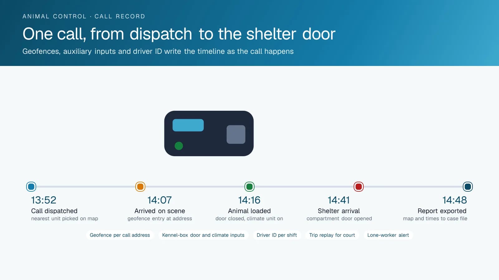
Animal control runs a small fleet on a big caseload: stray pickups, welfare checks, bite investigations, dangerous-dog complaints, wildlife calls and the transport runs between the field, the shelter and the veterinary clinic. Officers work alone, often in places a dispatcher cannot see, and a large share of the calls end in a dispute about when the officer arrived, how long they stayed or whether they came at all. GPS tracking from High Point GPS puts every truck on one live map for dispatch and turns each call into a record: the address as a geofence, the arrival and departure times, the route there and the stops on the way to the shelter. A GPS tracking device covers the trucks, IOX-AUXM auxiliary inputs read the kennel-box doors and the climate unit that keeps an animal safe in the back, and driver ID attributes every trip to the officer on shift. When a resident says nobody came for the injured dog, the trip replay shows the truck at the address at 14:07 for nine minutes. When a bite case reaches court, the officer's timeline is already written. Engine-hours maintenance, electronic pre-trip inspections and after-hours use reports round out a platform the agency runs from the same High Point GPS platform database as the rest of the municipality, or on its own if it is a humane society under contract.
Common challenges
- Residents who say the officer never came, with no record beyond the officer's notes to say otherwise
- Dispatch sending the wrong officer to a call because nobody knows who is closest or who is already on a transport
- Animals in the kennel box on a hot day with no record of whether the climate unit was running or the doors were opened
- Bite and dangerous-dog cases that reach court months later, when the officer's memory of the timeline has faded
- Officers working alone at night on cruelty and hoarding calls with no way for dispatch to confirm they are safe
- Transport runs between shelters, clinics and the field that nobody can reconcile against the mileage and fuel bills
How High Point GPS helps
- Live location of every officer on one map for dispatch, with the nearest available unit visible when a priority call comes in
- Arrival and departure records at every call address through geofences created from the dispatch system or on the spot
- Kennel-box door and climate-unit status read from the truck's own circuits through IOX-AUXM auxiliary inputs
- Trip replay that shows the route, the speed and each stop for any truck on any day, ready for a complaint or a court file
- Driver ID with the IOX-NFCREADERA so every call, transport and mileage claim is attributed to the officer on shift
- Panic and lone-worker alerts, with the truck's location and the officer's last stop sent to dispatch
- AI dash cams on the trucks, with event-based clips for road incidents and a record of the scene on arrival
- Engine-hours maintenance, fault codes to the shop and electronic DVIR before each shift in the driver app
A time-stamped account of every call
The complaint always arrives the same way: a resident says they called about a stray, a dog left in a car or an injured raccoon and nobody came. The officer's log says otherwise, and the supervisor is left choosing between two accounts. With a geofence around each call address, the platform records the truck's arrival, the time on scene and the departure without the officer touching anything. The trip replay shows the route taken and the speed on the way. The supervisor answers the complaint in the time it takes to open the day's trips.
The same record carries the cases that go further. A bite investigation, a dangerous-dog hearing or a cruelty prosecution can reach a courtroom a year after the call, and the officer is asked what time they arrived and how long they stayed. High Point GPS sets up the High Point GPS platform so that a call's timeline is exported as a report with the date, the address, the arrival, the departure and the map. The agency attaches it to the case file the week the call is closed rather than reconstructing it from memory later.
Dispatching the closest officer, not the one who answers the radio first
Animal control dispatch works from a queue of calls with priorities that shift by the hour: an aggressive dog at a school takes precedence over a barking complaint, and a transport already loaded with a sedated animal cannot be diverted. On the live map, the dispatcher sees where every truck is, which ones are stopped at an address and which are moving toward the shelter. The nearest available officer is a glance, not a series of radio checks. Status from the kennel-box inputs shows which trucks are carrying animals and which are empty.
For agencies that dispatch from a case-management system, High Point GPS connects the two through the High Point GPS API, so a new call creates the geofence and the assignment reaches the officer in the truck. Smaller agencies run dispatch from the High Point GPS platform itself with routes and messages to the driver's device. Either way, the record of who was sent, when they were sent and when they arrived lives in one place, and the end-of-month response-time report for the municipality comes from that record rather than from a spreadsheet the supervisor fills in by hand.
The animal in the back of the truck
The part of the fleet nobody sees is the kennel box. A dog in a steel compartment on an August afternoon depends on the climate unit and on the officer not stopping for long on the way to the shelter. An IOX-AUXM module on the GPS tracking device reads whether the climate unit is running and when each compartment door is opened and closed, and stamps each event with the time and the location. The record of a transport then reads: loaded at the call address at 14:16, unit on, doors closed, arrived at the shelter at 14:41, doors opened.
That record answers the welfare complaint about an animal that arrived in distress, and it protects the officer who did everything right. A rule can also fire an alert to dispatch if a truck with a loaded compartment is stopped for longer than a set time, or if the climate unit is off while the truck is carrying. For transports to a clinic or a partner shelter in another city, the trip is stored on the device when coverage drops and uploaded when it returns, so a rural run is recorded end to end.
Officer safety, vehicle policy and the shop
Officers walk into hoarding houses, cruelty scenes and confrontations with owners, often alone and often after dark. A panic button wired to the GPS tracking device sends the truck's location and the officer's last stop to dispatch, and a lone-worker rule flags a truck stopped at an address well past the expected duration of the call. AI dash cams add a road-facing record of the approach to the scene and, if the agency wants it, a driver-facing camera for the incidents that happen in the cab.
The rest is the ordinary discipline of a small municipal fleet. Driver ID through the IOX-NFCREADERA attributes each trip and mileage claim to the officer on shift, and after-hours and personal-use reports support the agency's vehicle policy. Electronic DVIR in the driver app records the pre-shift inspection of the truck and the kennel box. Engine-hours maintenance reminders and fault codes keep the trucks in service, which matters when the agency has three of them and a caseload that does not pause for a breakdown.
Frequently asked questions
Can it prove an officer responded to a call?
Yes. A geofence around the call address records the truck's arrival and departure, and the trip replay shows the route and the stops on the way. The timeline exports as a report with the map, which the agency attaches to the case file for complaints, bite investigations and court.
Does it monitor the kennel box and the climate unit?
It can. An IOX-AUXM module reads the climate unit and each compartment door through the truck's own circuits, and stamps each event with the time and the location. A rule alerts dispatch if a loaded truck is stopped too long or if the unit is off while an animal is aboard.
How does dispatch know which officer is closest?
Every truck is on the live map with its current status, including whether it is stopped at an address or carrying an animal. The dispatcher picks the nearest available unit from the map. Agencies with a case-management system can connect it through the High Point GPS API so calls and assignments flow both ways.
What about officer safety on night calls?
A panic button wired to the GPS tracking device sends the truck's location to dispatch, and a lone-worker rule flags a truck stopped at a call well past the expected time. Dash cams add a record of the approach. High Point GPS configures the rules with the agency's own thresholds.
We are a humane society under contract, not a city department. Does that change anything?
No. The agency runs its own High Point GPS platform database, and the response records serve the contract's reporting to the municipality the same way. If the municipality already uses High Point GPS, the two databases can share reports without sharing access. High Point GPS sets up either arrangement and supports the agency directly, whoever owns the trucks.
Related solutions
Related guides
- Fleet Dispatch and Tracking for Public Sector →
- Municipal Fleet Tracking: A Buyer's Guide for Cities, Counties and Public Works →
- How Geofencing Works for Fleet Tracking →
- Timeline Map: Replaying a Trip Minute by Minute to Settle a Dispute →
- IOX-NFCREADERA: Driver ID by NFC Tap, So Every Trip Has a Name on It →
- GeoX: Documenting a Collision From the Cab Before the Tow Truck Arrives →
Get a free quote
What are you looking for?