
Industry
GPS Fleet Tracking for Law Enforcement & Police Fleets
GPS tracking for police fleets that records where every patrol car is, when the light bar and siren were on and what the vehicle did on a call, with pursuit driving kept out of the driver score and take-home car policy enforced from the data.

Updated September 21, 2026
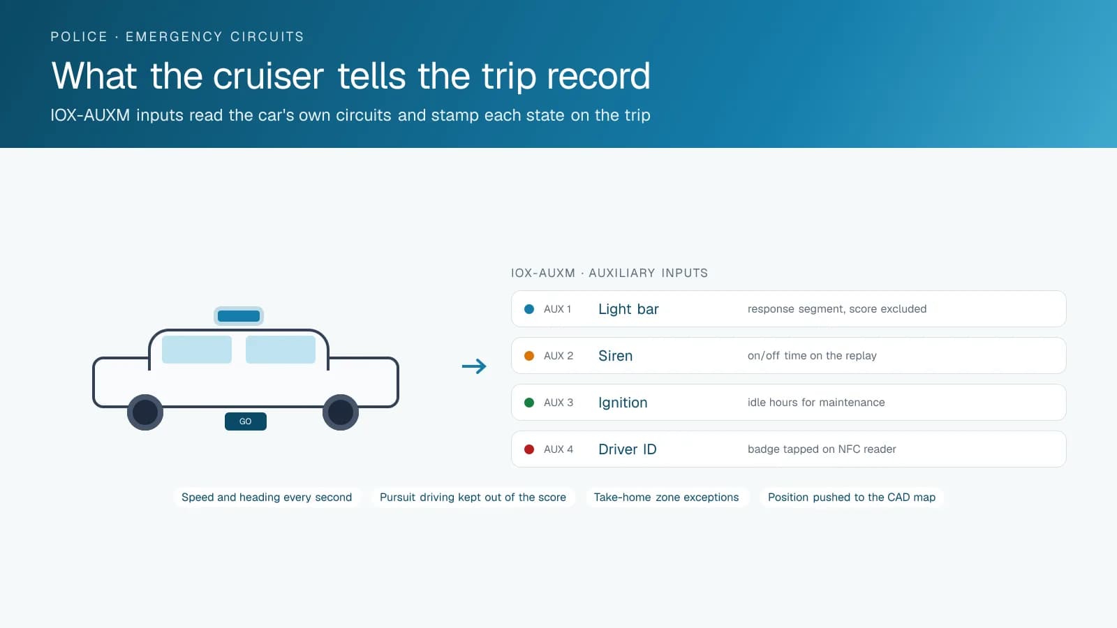
A police fleet is the most visible fleet in any municipality and the one whose records are examined most closely after the fact. A complaint about a cruiser's speed, a collision during a response, a question from council about take-home cars: each one ends with someone asking where the car was and what it was doing. GPS tracking for law enforcement puts every patrol, unmarked and support vehicle on one map for the fleet office, and keeps a trip record that stands on its own in a review. The Geotab GO device reads the light bar and siren through the IOX-AUXM auxiliary inputs, and every trip shows when the vehicle was responding and when it was on routine patrol. Driving during a lights-and-siren response is separated from routine driving in the score, which keeps an officer's coaching report about the driving that policy actually governs. Take-home cars carry a policy zone and an off-duty rule, and the report shows the exceptions rather than the fleet manager searching for them. Engine hours drive maintenance, because a cruiser idles through most of its life and mileage understates its wear. High Point GPS builds the MyGeotab database around the department's structure, with access split between fleet services, supervisors and internal affairs, and with the data staying in the department's hands. Where the agency runs computer-aided dispatch, the open API carries vehicle position into the CAD map.
Common challenges
- Citizen complaints about cruiser speed with no independent record of whether the car was on a call
- Driver scoring that penalizes officers for pursuit and emergency response driving, which undermines the whole program
- Take-home car policies that exist on paper with no way to see off-duty or out-of-zone use
- Collision reviews that rest on the officer's account and the other driver's account, with nothing in between
- Cruisers maintained on mileage when most of their engine wear comes from idling at the roadside
- A CAD map that shows unit status but not where the unit actually is between status updates
How High Point GPS helps
- Live position of every marked, unmarked and support vehicle on one map, with access set by rank and role
- Light bar, siren and other emergency circuits read from the vehicle through the GO device's IOX-AUXM inputs and stamped on every trip
- Driver scoring that excludes segments with lights and siren active, so routine driving is what gets coached
- Evidence-grade trip replay with second-by-second speed, heading and emergency-equipment status for any vehicle on any date
- Take-home car zones and off-duty rules with an exceptions report for the fleet office and the officer's supervisor
- Collision data from the GO device's accelerometer with a reconstruction record for the review board and the insurer
- Maintenance scheduled on engine hours and fault codes, which reflects idle time that mileage never shows
- Vehicle position pushed to the agency's CAD or records system through the open API, with the department owning the data
A Trip Record That Holds Up in a Review
When a resident reports a cruiser at high speed on a residential street, the review needs three facts: where the car was, how fast it was going and whether it was responding to a call. The trip replay shows all three on one screen. Position and speed come from the GO device several times a second when the vehicle is moving; the light bar and siren states come from the vehicle's own circuits through the IOX-AUXM module. A segment at 95 km/h with lights and siren on reads differently from the same segment with them off, and the record shows which it was without anyone having to remember.
The same record serves the department when the complaint is unfounded. An officer accused of speeding past a school at dismissal is cleared by a replay that shows the cruiser at 38 km/h. A claim that a unit took twenty minutes to arrive is answered by the dispatch time, the departure time from the previous location and the arrival time at the scene. High Point GPS sets up report access so internal affairs, fleet services and the shift supervisor each see what their role needs, and so the record cannot be edited by any of them. Retention is set by the department, and the record for a given date is available for as long as the policy says it must be.
Scoring the Driving Policy Governs, Not the Pursuit
A driver-behaviour program fails in a police fleet the moment it counts a pursuit as a speeding event. Officers stop reading their scores and supervisors stop using them. High Point GPS configures the rules so that any segment with the emergency lights active is excluded from speeding, hard braking and cornering scores. What remains is the driving that department policy covers: the drive to the station, the patrol loop, the run to court. That is the driving where a habit of rolling stops or a heavy right foot can be coached, and where a coaching conversation starts from a specific trip rather than a general impression.
The excluded segments are not discarded. They are held in a separate response-driving report that the pursuit review committee or the training unit can read on its own terms, with the speed profile, the duration of lights-and-siren operation and the route taken. AI dash cams add the road-facing view when the department chooses them, with video pulled by trip and by event, and with retention and access set by the department's own policy. A supervisor reviewing a pursuit sees the moment the lights came on, the top speed reached and the point where the pursuit was called off, on the same map the officer drove.
Take-Home Cars, Off-Duty Use and the Council Question
Take-home car programs are defended to council on the strength of their policy, and the policy is only as good as the ability to show it is followed. High Point GPS configures each take-home vehicle with a home zone, a jurisdiction boundary and the officer's shift pattern. Driving outside the boundary, or during hours the policy defines as off duty, appears on an exceptions report for the fleet office and the officer's supervisor. Most weeks the report is short; the point is that it exists and that it is complete.
Driver identification through the IOX-NFCREADERA reader attributes each trip to a badge, which matters for pool cars and for the unmarked units that several officers share. Geofences around the impound lot, the range, the courthouse and the station record arrival and departure times without anyone writing them down. When council asks how many kilometres take-home cars drive off duty, the answer is a report, not an estimate. The same report shows the hours a car spent parked at the courthouse or the range, which is useful when the fleet office is asked whether the department has more cars than it needs.
Maintenance on Engine Hours and Data in the CAD Map
A cruiser idles at traffic stops, at scenes and at the roadside for hours a shift. An odometer-based service schedule sees a car that drove 30,000 kilometres; the engine has done the work of twice that. High Point GPS sets maintenance reminders on engine hours as well as distance, and routes engine fault codes to fleet services as the vehicle logs them. A charging-system fault from a car carrying a laptop, a radio and a light bar reaches the shop before it strands the unit at 3 a.m. Electronic DVIR in the Geotab Drive app gives the start-of-shift walkaround a time stamp and sends defects to the shop.
Agencies that run computer-aided dispatch usually want vehicle position in the CAD map rather than in a second application. The open Geotab API feeds live position, heading and emergency-equipment status to the CAD or records system, and High Point GPS builds the connection or a custom add-in when the vendor has no ready integration. The department's data stays in its own MyGeotab database, under its own retention policy. The connection runs both ways when the agency wants it: a unit status set in CAD can appear on the MyGeotab map, and a geofence arrival at the station can close out a call, which removes one radio transmission from every return to base.
Frequently asked questions
Will pursuit driving count against an officer's driver score?
No. High Point GPS configures the rules so that any segment with the emergency lights active, as read from the vehicle's light bar circuit through the IOX-AUXM module, is excluded from speeding, braking and cornering scores. Those segments go to a separate response-driving report for the review committee or the training unit.
How does the system know the lights and siren were on?
An IOX-AUXM module on the GO device reads the light bar, siren and other emergency circuits directly from the vehicle. Each state change is time-stamped in the trip record, so a replay shows exactly when the equipment was switched on and off along the route.
Can the trip record be used in an internal review or in court?
The trip record is stored on Geotab's platform, is time-stamped from GPS and cannot be edited from MyGeotab. Departments routinely use replays in internal reviews and collision investigations. Whether a particular record is admissible in a given court is a question for the department's counsel.
Can vehicle position feed our CAD system?
Yes. The open Geotab API provides live position, heading and auxiliary-input status. High Point GPS builds the connection to the agency's CAD or records system, or a custom add-in where the vendor has no existing integration, with the department keeping ownership of the data.
How is access controlled inside the department?
MyGeotab access is set by role and group. Fleet services sees maintenance and utilization, shift supervisors see their units, and internal affairs or professional standards sees trip replays for a review. High Point GPS sets up the groups to match the department's structure and its policy on who may view what.
Related solutions
Related guides
- Fleet Dispatch and Tracking for Public Sector →
- Municipal Fleet Tracking: A Buyer's Guide for Cities, Counties and Public Works →
- What Is a Geotab IOX and What Does It Do? →
- Collision Reconstruction in Geotab: Reading the Seconds Before and After an Impact →
- Timeline Map: Replaying a Trip Minute by Minute to Settle a Dispute →
- Fleet Maintenance: Engine Hours vs. the Calendar →
Get a free quote
What are you looking for?