
Industry
GPS Fleet Tracking for Utilities & Line Crews
GPS tracking for electric, gas, water and telecom utility fleets that shows the control room where every bucket truck and crew is during an outage, records aerial-device and PTO use for safety and maintenance, and gives the regulator the restoration and inspection records it asks for.
Updated September 21, 2026
A utility fleet is judged on the night the lights go out. GPS tracking for utility fleets puts every bucket truck, digger derrick, service van and pickup on one live map for the control room and the storm desk, so crews are sent to the outage nearest them, mutual-aid crews arriving from out of region are tracked from the moment they check in, and the restoration timeline is a record rather than a reconstruction. The same Geotab GO device that reports position reads the aerial device, the outriggers and the PTO through its auxiliary inputs, so the platform knows when a bucket was in the air and for how long, which feeds both the annual aerial-device inspection schedule and the incident file if something goes wrong. Electronic pre-trip inspections cover the truck and the aerial device, engine-hours and PTO-hours maintenance keep trucks that idle all day at a job site serviced on the hours they work, and driver-behaviour reporting and AI dash cams give the safety department the record a regulator, an insurer or a union grievance asks for. Because a utility runs a municipal-style fleet alongside its line trucks, the whole fleet shares one MyGeotab database with each department seeing its own vehicles.
Common challenges
- Storm-desk dispatch by radio and whiteboard, with no live picture of where crews and mutual-aid trucks are
- Restoration timelines reconstructed after the event for the regulator's report
- No record of aerial-device and outrigger use, so inspection intervals and incident investigations rely on memory
- Trucks that idle at job sites all day and are maintained on mileage that understates the wear
- Pre-trip inspections of the truck and the aerial device on paper, filed in a cab
- Driver-behaviour and camera records the safety department cannot produce for a grievance or a claim
How High Point GPS helps
- Live location of every bucket truck, digger derrick, service van and pickup on one map for the control room and the storm desk
- Outage and work-order geofences that record crew arrival and departure, feeding the restoration timeline automatically
- Aerial device, outriggers and PTO read through the GO device's auxiliary inputs, logged with each stop
- Mutual-aid crew onboarding: visiting trucks added to the map for the duration of the event and removed after
- Electronic DVIR with the truck- and aerial-device checklist, with defects routed to the garage the same morning
- Engine-hours and PTO-hours maintenance reminders, with fault codes from the engine sent to the garage as they appear
- Driver scoring and AI dash cams for the safety file, with events reviewed by trip and retention set by the utility
- Open API integration with the outage-management, work-order and asset systems the utility already runs
The Storm Desk's Live Map
When a storm takes down a feeder, the storm desk needs to know where every crew is, which trucks are closest to each outage and how long each one has been on scene. With every truck on the live map and the outage locations drawn as geofences, that picture is on the wall instead of in someone's head. Crews are dispatched to the nearest outage on their way rather than the next one on the list, the arrival at each site is recorded as the truck enters the geofence, and the restoration timeline the regulator will ask for is being written as the night goes on.
Mutual-aid crews from another utility are added to the map when they check in, tracked for the duration of the event and removed when they leave, so the storm desk sees them like its own trucks. High Point GPS connects the live position to the utility's outage-management system through the API, so the OMS and the map agree on which crew is where.
Knowing When the Bucket Was in the Air
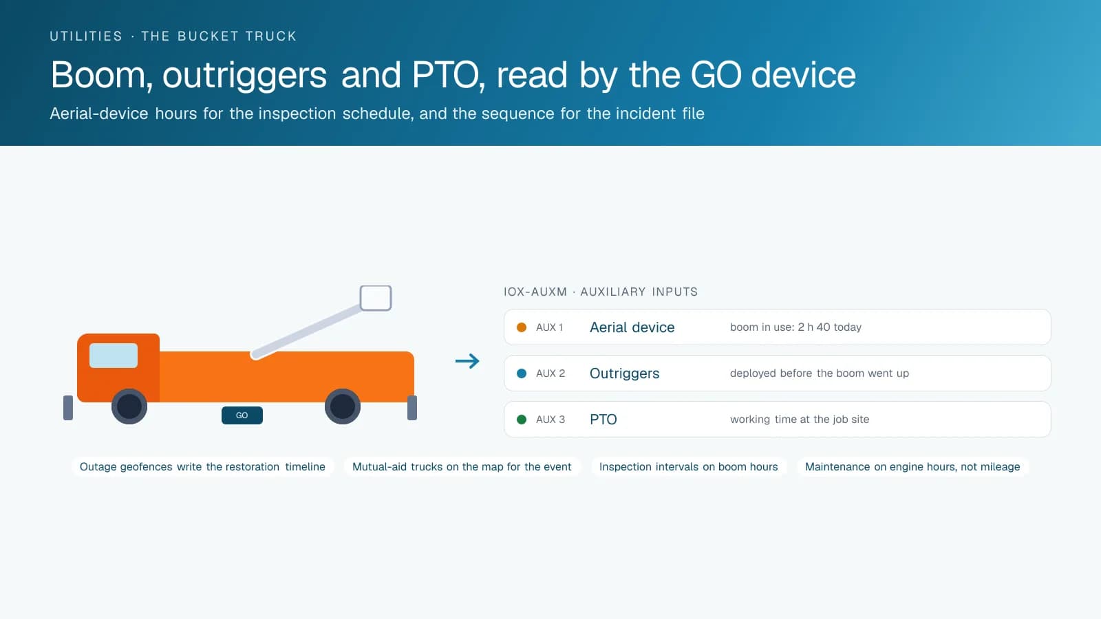
An aerial device is the most regulated piece of equipment on the truck. Annual inspections, dielectric testing and the incident investigation after a contact all depend on knowing how much the device has been used. An IOX-AUXM module on the GO device reads the aerial device's engagement, the outriggers and the PTO, so each stop in the trip record carries how long the boom was in use and whether the outriggers were deployed before it went up. The inspection schedule runs on those hours, and the incident file has the sequence of events from the truck's own circuits.
The same inputs serve the day-to-day. A truck that shows PTO time at a job site shows the crew was working; a truck that sat with the engine idling and the PTO off for two hours is a question for the supervisor. Job costing per work order draws on the same record.
Inspections and Maintenance on the Hours That Count
The pre-trip inspection of a bucket truck covers the truck and the aerial device, and on paper it is the form most likely to be filled in from memory in the cab. Electronic DVIR in the Geotab Drive app walks the operator through both checklists, time-stamps each item and routes a defect to the garage before the truck leaves the yard. High Point GPS builds the checklist to match the utility's own procedure and the regulator's expectations.
Utility trucks idle. A bucket truck may run all day at a job site and add thirty kilometres to its odometer, and mileage-based maintenance misses that. Engine-hours and PTO-hours reminders schedule service on the hours the truck actually works, and engine fault codes reach the garage as they are logged, so the truck is repaired on a planned day rather than failing during a storm.
The Safety File and the Rest of the Fleet
A utility's safety department answers to a regulator, an insurer and, often, a union. Driver-behaviour scoring per operator, speeding and harsh-driving events, dash-cam footage retrieved by event and the coaching record for each one give the department a file it can produce on request. AI dash cams with driver-facing detection matter most on the long drives home after a storm shift. The utility sets the retention and the access rules, and the platform enforces them.
Line trucks are one part of a utility fleet that also includes meter readers, inspectors, engineers and administrative vehicles. All of it runs on the same MyGeotab database, with each department seeing its own vehicles and the fleet manager seeing everything. The open API feeds the utility's work-order, asset and fuel systems, and High Point GPS builds custom add-ins when a utility wants a view of its own, such as a storm board showing crews by feeder.
Frequently asked questions
Can it record aerial-device and outrigger use?
Yes. An IOX-AUXM module on the GO device reads the aerial device, the outriggers and the PTO through the truck's own circuits, so each stop shows how long the boom was in use and whether the outriggers were deployed. That feeds the inspection schedule and the incident file.
Does it integrate with our outage-management system?
Yes, through the platform's open API. High Point GPS connects live position and crew status to the OMS, work-order and asset systems the utility runs, so the storm desk's map and the OMS agree on which crew is where.
How are mutual-aid crews handled during a storm?
Visiting trucks are added to the map when they check in, with a plug-in device or their own platform's data where the visiting utility also runs Geotab, tracked for the event and removed when they leave. The storm desk sees them like its own crews.
Can different departments see only their own vehicles?
Yes. One MyGeotab database holds the whole fleet, with groups for line crews, meter readers, inspectors and administration. Each department sees its own vehicles and reports, and the fleet manager sees everything.
What does it give the safety department for a grievance or a claim?
A file: the driver's score and events, the dash-cam footage for the trip, the coaching record, the inspection completed that morning and the maintenance history of the truck. It is retrieved by trip and by vehicle, in minutes.
Related solutions
Related guides
- Fleet Dispatch and Tracking for Public Sector →
- What Is a Geotab IOX and What Does It Do? →
- Fleet Maintenance: Engine Hours vs. the Calendar →
- Geotab DVIR: How Digital Vehicle Inspection Reports Work →
- Fleet Dash Cams With Live View: What Live Streaming Shows and When It Is Actually Used →
- How Geofencing Works for Fleet Tracking →
Get a free quote
What are you looking for?