
Industry
GPS Fleet Tracking for Traffic Control & Pavement Marking
GPS tracking for traffic control and pavement marking fleets: geofenced lane closure windows, painted kilometres from the pump circuit, dash cams at night.
Updated September 22, 2026
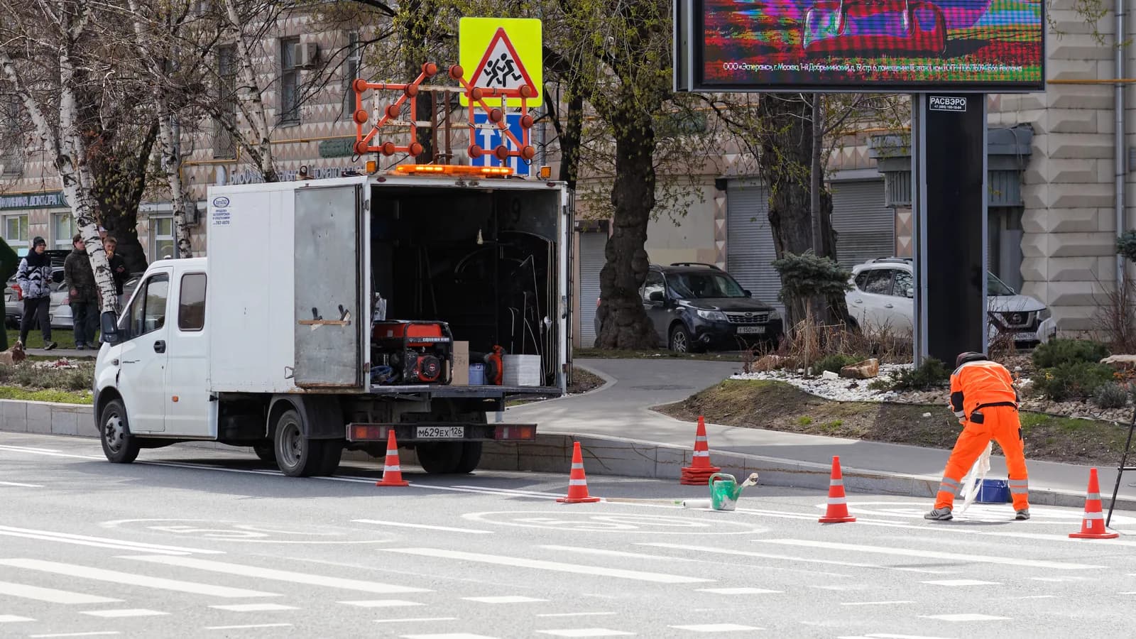
Traffic control and pavement marking are the trades that work inside the road authority's own rules: a lane may close at 9:00 p.m. and must reopen by 5:00 a.m., a line-painting pass is paid by the kilometre, and a crash truck must be in position before anyone steps onto the pavement. Every one of those conditions is checked after the fact, by an inspector or by a claims adjuster. GPS tracking from High Point GPS puts a GPS tracking device in every crash truck, arrow board truck, crew van and line-painting truck. The geofence around each closure records when the first truck arrived and when the last one left. That is the closure window, in the fleet's own data, ready for the authority's report. On the paint truck, IOX-AUXM inputs read the paint pump, the bead dispenser and the carriage, and the platform shows where paint was actually applied and for how many kilometres. Arrow boards, attenuators, message signs and barricades that stay on site overnight carry Bluetooth tags, read by any passing truck, so the yard knows what is where. Most of the work happens at night, beside live traffic, and the AI dash cams facing the road and the driver record the setups, the pick-ups and the close calls the crew talks about at the next safety meeting. Driver hours, inspections and heavy-truck compliance run through the driver app in the same cab.
Common challenges
- Closure windows the road authority disputes, with no record of when the first truck arrived and the last one left
- Line-painting invoices billed per kilometre from an operator's estimate rather than from where the paint pump actually ran
- Arrow boards, attenuators and message signs left on sites overnight, and nobody sure which site or whether they are still there
- Night shifts and split crews whose hours and inspections live on paper until the end of the week
- Near misses and intrusions into the work zone with no video to support a claim or a report to the authority
- Crash trucks and paint trucks serviced by calendar while the attenuator, the pump and the compressor wear by the hour
How High Point GPS helps
- Geofence arrival and departure records for every closure, producing the lane closure window the road authority asks for
- Paint pump, bead dispenser and carriage states read through IOX-AUXM inputs, tied to the position on the road
- Kilometres of line painted per pass, per truck and per contract, exported to back per-kilometre invoices
- Live map at night showing the crash truck, the arrow board truck and the crew vehicles in position before work begins
- Bluetooth tags on arrow boards, attenuators, message signs and barricades, with last-seen location from any passing truck
- AI dash cams facing the road and the driver, with event clips for work-zone intrusions and backing incidents
- Hours of service, electronic DVIR and driver ID in the driver app for night crews and heavy trucks
- Maintenance on engine and PTO hours for paint pumps, compressors and attenuator trucks, with fault codes sent to the shop
The closure window, proved by the trucks
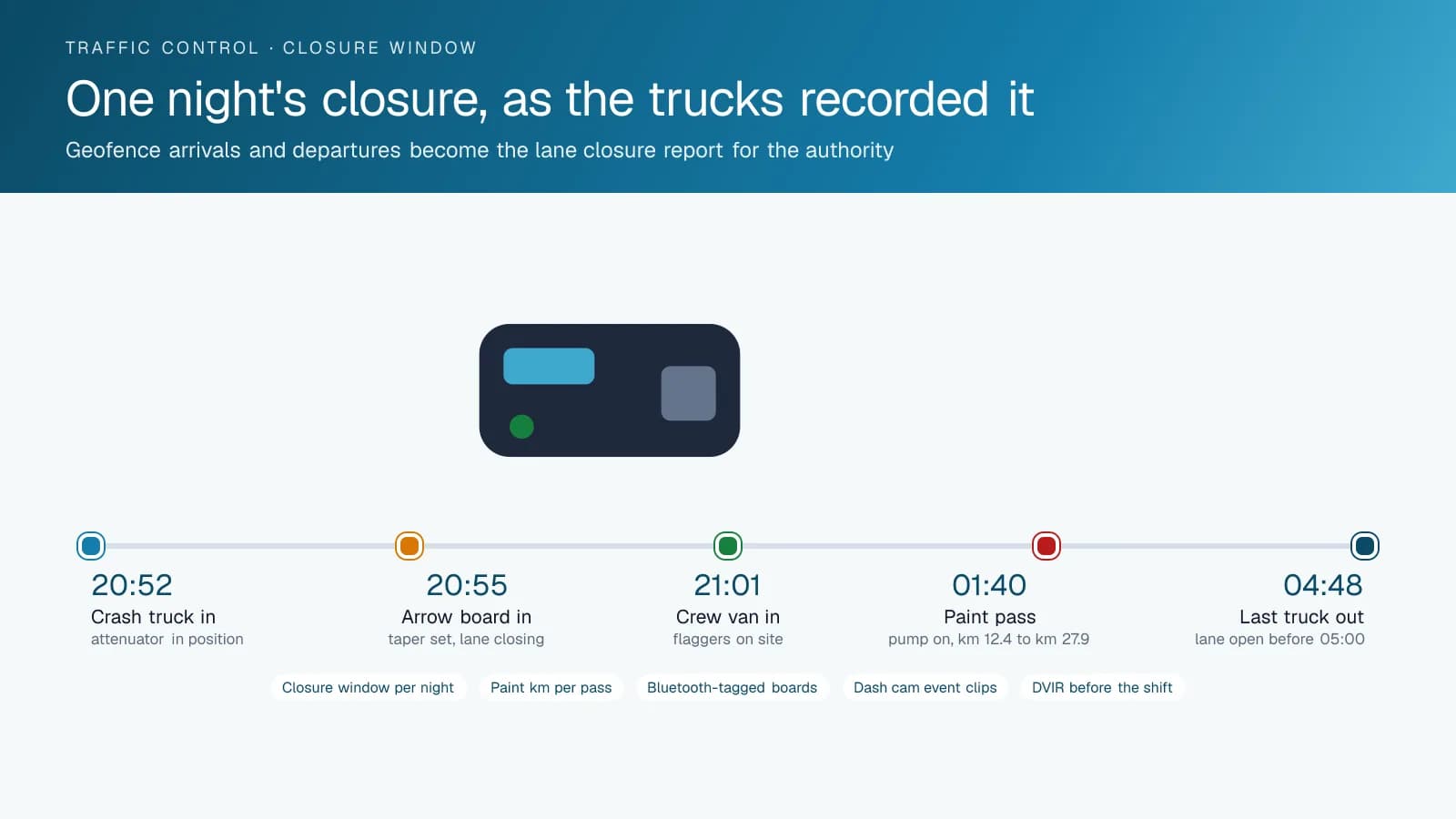
A lane closure permit says the work zone may be set at 9:00 p.m. and must be clear by 5:00 a.m. The authority's inspector drives through at 5:20 and finds a cone. The contractor's answer used to be a foreman's word. With a geofence drawn around the closure, the GPS tracking device in each truck records the arrival of the crash truck at 8:52, the arrow board truck at 8:55 and the crew van at 9:01. It records the last truck leaving at 4:48. The report lists every vehicle, in and out, and the trip replay shows the pick-up order. High Point GPS sets the geofences from the permit list, or the dispatcher draws one when the night's work is assigned.
That same record answers the harder questions. When a motorist claims they hit a barrel at 4:30 in a zone that should have been open, the replay shows whether the crew was still working and where the crash truck sat. When a project bills by the shift and the authority asks whether a second crash truck was really on site, the geofence shows the truck inside the zone for six hours. Contracts with liquidated damages for late reopening are settled on the departure time of the last truck rather than on memory. The office exports the closure report by night, by contract or by month and attaches it to the invoice.
Paint pump, beads and the kilometres billed
A line-painting truck is paid for the line it puts down, and the invoice says how many kilometres. An IOX-AUXM module on the GPS tracking device reads the paint pump, the bead dispenser and the carriage lift as on or off, and each state change is tied to a position on the road. The High Point GPS platform then shows the pass on the map: paint on at kilometre 12.4 of the highway, off at 27.9, on again after the interchange. Distance with the pump running is the kilometres painted. A truck with the carriage down and the pump off is deadheading to the next section, and the report says so.
The office builds the invoice from the pass report rather than from a tally sheet, and the authority's inspector can be shown the same map when a quantity is questioned. The shop uses the same inputs for maintenance: pump hours and compressor hours schedule seals and filters, and engine fault codes reach the shop as they are logged, which matters for a truck that runs one season and sits the next. Fuel-card integration matches fills to the truck and compares consumption with pump hours, so a paint truck burning more than its passes explain gets a look before the season ends.
Night work, split crews and the gear left behind
Traffic control fleets run at night, in several places at once, with crews that change composition by the shift. The live map shows the dispatcher where each crash truck, arrow board truck and crew vehicle is, and whether the attenuator truck is in position before the flaggers step out. Drivers log in with an NFC card through IOX-NFCREADERA, so a shared truck's trip is attributed to the person who drove it. The driver app keeps hours of service for the drivers who need it and the electronic DVIR for every truck, including the attenuator check on the crash truck, before it leaves the yard for the night.
The equipment is the other headache. Arrow boards, portable message signs, attenuators and barricade sets stay on a site for days, and a yard manager rarely knows which site holds which. A Bluetooth tag on each piece is read by any company truck that passes within range, and the High Point GPS platform shows the last-seen location and time. When a job closes and a message sign is missing, the last-seen record names the site and the truck that saw it. Battery-powered trackers on the higher-value boards report on their own, and a board that moves outside its site geofence at 3:00 a.m. raises an alert.
Working beside live traffic
No fleet works closer to moving cars than a traffic control crew. A crash truck's job is to be hit, and a paint truck spends its shift at walking pace with traffic passing on one side. AI dash cams facing the road record intrusions into the work zone, drivers who cut the taper and the impact when it comes; the driver-facing camera records the moments before a backing incident during a pick-up. Clips are saved by event and retrieved by trip, and the office has the video and the position record before the insurer or the authority asks. The same clips become the material for the next tailgate safety meeting.
Driver scoring for these fleets is set for how the work is done. Speeding thresholds are tightened inside work-zone geofences, where the crew's own trucks are the traffic, and harsh braking and cornering are weighted for trucks carrying an attenuator or a paint load. Idling is reported separately inside a closure, where a crash truck idles by design, and on the road, where it does not. High Point GPS builds the rules with the safety manager, installs rugged GPS tracking devices where the cab gets abuse, and sets the reports up so a supervisor coaches from a specific night on a specific highway.
Frequently asked questions
Can it prove when the lane was closed and reopened?
Yes. A geofence around the closure records each truck's arrival and departure, and the closure report shows when the first truck arrived and the last truck left, with the trip replay for the pick-up order. The report is exported by night or by contract and attached to the invoice or the road authority's submission.
How does it measure the kilometres of line painted?
An IOX-AUXM module reads the paint pump, bead dispenser and carriage circuits on the truck, and each state change is tied to a GPS position. Distance travelled with the pump running is the painted length, shown on the map by pass and totalled per truck and per contract for per-kilometre invoices.
Can we track arrow boards and message signs left on a site?
Yes. Bluetooth asset tags on boards, signs, attenuators and barricade sets are read by any company truck passing within range, and the High Point GPS platform shows the last-seen location and time. Higher-value boards can carry battery-powered trackers that report on their own and raise an alert when they leave the site geofence outside working hours.
Do the crash truck and paint truck drivers need an ELD?
It depends on the vehicle and the radius. Heavy trucks operating beyond short-haul limits fall under the ELD mandate in Canada and the US. The driver app handles hours of service and electronic DVIR for the drivers who need it, and High Point GPS sets each truck's ruleset to match how it is used.
What does the dash cam record on a night shift?
Road-facing cameras record the setup, the traffic passing the taper, any intrusion into the work zone and an impact on the crash truck. The driver-facing camera records the cab during a backing or pick-up incident. Clips are saved by event and retrieved by trip, with the fleet setting retention and access.
Related solutions
Related guides
- How Geofencing Works for Fleet Tracking →
- What Is an IOX Port and What Does It Do? →
- IOX-BT and Bluetooth Asset Tags: How They Work and What to Tag →
- GPS Asset Tags vs. Powered Trackers: Which to Use →
- Dash Cam Footage and Insurance Claims →
- IOX-NFCREADERA: Driver ID by NFC Tap, So Every Trip Has a Name on It →
Get a free quote
What are you looking for?