
Industries
Plow Tracker Maps: How Cities Show Residents Where the Snow Plows Have Been
A plow tracker is a public map that shows residents where a city's snow plows have been, built from GPS on each truck. How it works and what a city needs.
What Is a Plow Tracker?
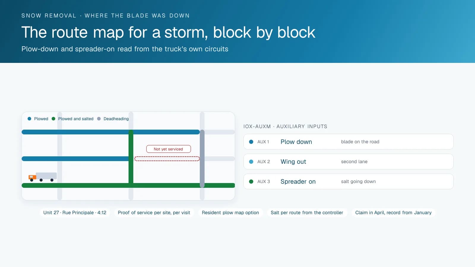
A plow tracker is a public map, on a city website or in an app, where residents check whether the snow plows have reached their street. Most are built from GPS tracking devices on the plows and salt spreaders: each truck reports its position, the city's software matches those positions to streets, and the map colours each street by how recently a plow went by.
Residents type "plow tracker" or "where's my plow" into Google during a storm; in Quebec they type « info neige ». Behind those searches sit two kinds of map. A pass-based map, such as New York City's PlowNYC or Columbus's Warrior Watch, shows where the trucks have driven and when. A status map, such as Quebec City's Info-Déneigement or Montreal's snow loading map in the 311 Montréal app, shows the stage of an operation (planned, in progress, done) by street or sector. Many cities publish one or the other; the choice shapes what residents can learn from it.
How Does a Snow Plow Tracking Map Work?
The map starts with automatic vehicle location (AVL): a GPS tracking device on every plow, salter and sidewalk machine. The device records position and speed and sends them over the cellular network to the telematics platform the public works department uses to run the storm. Where the truck is wired for it, the same device also reports the state of the equipment through auxiliary inputs: blade down, wing out, spreader on.
The public map does not read the trucks directly. It reads a filtered copy of the AVL feed through an API, snaps each point to a street segment and stores the time of the last pass. The map then draws streets in bands such as "plowed in the last hour" or "3 to 6 hours ago", and an address search zooms to the resident's block.
The equipment inputs matter more than most cities expect. Without them, the system only knows that a truck drove down a street, not that it plowed it. A Winter Maintenance Review presented to Toronto's Executive Committee in July 2025 found that the City's system "logs whether a plow or salter has driven a route, and this is used as a proxy for completion", and that the systems "were not designed to measure final conditions on the ground." A blade-down input closes part of that gap; nothing on the truck measures how clear the pavement is afterwards.
Which Delay and Privacy Choices Does a City Make?
Every city that publishes a plow map makes the same handful of decisions, and the published maps show the range.
Delay. St. Catharines, Ontario, runs its Where's My Plow? map on a 15-minute delay and says the delay is "for safety". Cleveland's snow map also reports on a 15-minute delay. A delay keeps residents from chasing a truck down the street or waiting for it at the curb, and it gives the operations centre time to correct bad points before the public sees them.
What to show. Some maps show the trucks themselves; others show only the streets they have serviced. Columbus lets residents filter serviced streets by the last 3, 6, 12, 24 or 72 hours. PlowNYC colours streets in bands from "0 to 1 hours ago" to "36+ hours ago". A street-only map answers the resident's question (has my street been done?) without publishing where each operator is at a given minute.
Which vehicles. St. Catharines shows City-operated vehicles only: contractor vehicles "aren't yet GPS-enabled" and sidewalk plows are planned for a later phase. A city that contracts out part of its routes has to decide whether contractors feed the public map, and write that into the contract.
When it runs. Cleveland's tracker is "only active during snow events", and PlowNYC displays "not tracking vehicles at this time" between storms. Driver names, unit history and anything outside the storm window stay off the public page.
Disclaimers. PlowNYC warns that "a plowed or salted street will not show blacktop right away." Quebec City says the flashing lights on the street prevail over its web page, and Montreal says posted parking signs prevail over its open data. Each of these lines answers a call the 311 centre would otherwise take.
What Do Residents See on City Plow Maps in Canada and the US?
Seven public maps, described from each city's own pages. Features change between seasons, so check the city's page before relying on any one detail.
| City | Map or app | What residents see |
|---|---|---|
| Montreal, QC | 311 Montréal app (replaced the Info-Neige MTL app) | Progress of snow loading operations in every borough on a map, a notice when the status of the street where your car is parked changes, a notice 60 minutes before loading, and free parking lots |
| Quebec City, QC | Info-Déneigement and the flashing lights map | Your street's priority level by address, progress of the snow removal operation by priority level, and whether the parking ban lights on your street are off, scheduled or on |
| Toronto, ON | PlowTO | A City map of snow clearing activity during the winter season; it is offline in summer for maintenance |
| St. Catharines, ON | Where's My Plow? | Where City plows have been, on a 15-minute delay, updated every 15 minutes; no arrival times |
| New York City, NY | PlowNYC | Streets coloured by time since DSNY vehicles last passed, and each street's snow removal designation (Critical, Narrow, Sector) |
| Columbus, OH | Warrior Watch | Streets serviced in the last 3 to 72 hours, with each road's priority (arterial, collector residential, local residential) |
| Cleveland, OH | Snow map | How recently each street was plowed, active only during snow events, on a 15-minute delay |
Montreal: From Info-Neige to 311 Montréal, and the Open Data Behind It
For years, « Info-Neige » meant the Info-Neige MTL app, run by the company SideKick under a contract with the City. The City did not renew that contract, which ended in April 2025, and in December 2025 it launched its own app, 311 Montréal, which includes snow removal status and a live map (Noovo, January 9, 2026). The City's page for the app says you can follow snow loading operations in every borough, register where your car is parked to be notified when the street's status changes, and get a notice 60 minutes before a loading operation. Info-Neige MTL now runs independently as a paid app.
Montreal also publishes the data. The open data portal's "Déneigement des rues en arrondissements" dataset is an API for snow loading planning after a storm; it is secured, and developers request a token by email from the open data team. The portal also publishes snow removal sectors as geospatial files for each season. A Montreal plow map is a status map: it publishes where the snow loading operation stands, not where each truck is.
What Does a Public Works Department Need to Set Up a Plow Map?
A GPS tracking device on every unit that will appear on the map: plow trucks, salters, sidewalk machines and loaders, plus contractor trucks if the city wants complete coverage. Units without one leave streets looking untouched when they were done.
Equipment inputs on the trucks. Geotab's IOX-AUXM module reads four on/off signals, eight with two modules, on GO7 and newer devices, so blade, wing and spreader circuits can each report their state. For winter operations, Geotab's IOX-WRKS reads plow position and road and air temperature, works with more than 20 material spreader models and sends the data to the Public Works Add-In in MyGeotab; Geotab lists the GO9 and GO9+ as compatible devices, so the device model has to be checked first.
A street network with the city's priority classes, so the map can say which streets come first, the way Quebec City and Columbus do.
A read-only feed and publishing rules: which vehicles, which fields, what delay, what time window, and what the disclaimer says. The public page should read through a restricted account, never staff logins.
A test before the first storm. The inputs, the street matching and the delay all need a trial run in the fall, and the 311 team needs a short script for the calls the map will still generate.
High Point GPS works with municipalities and public works departments across Canada and the United States, in English and French. Our professional installers fit the GPS tracking devices and wire the plow and spreader inputs, and our Public Tracking Portal, built on the High Point GPS platform's API, publishes a read-only map of the vehicles and streets the city chooses. The public sector and snow removal pages cover the full winter setup.
Frequently asked questions
What is a plow tracker?
A plow tracker is a public map or app where residents check whether city snow plows have reached their street. It is usually built from GPS devices on the plows and spreaders, which report positions that the city matches to streets. The map then colours each street by how recently a plow passed, or by the stage of the snow operation.
Why do plow tracker maps have a delay?
Cities delay the map for safety and accuracy. St. Catharines and Cleveland both publish on a 15-minute delay, and St. Catharines says its delay is for safety. A delay keeps residents from chasing or waiting for a truck, and it gives the operations centre time to correct bad GPS points before they appear on the public page.
Does a plow tracker show when my street will be plowed?
Usually not. Most maps show where plows have been, not when they will arrive: St. Catharines says plainly that its tracker does not provide arrival times. Some cities add a planning layer instead. Quebec City shows each street's priority level by address, so residents can see where their street falls in the order of the snow removal operation.
What replaced the Info-Neige app in Montreal?
The City of Montreal's own app, 311 Montréal, launched in December 2025 after the City ended its contract for Info-Neige MTL. The 311 app shows snow loading progress in every borough on a map, notifies you when the street where your car is parked changes status, and sends a notice 60 minutes before a loading operation.
What equipment does a city need for a public plow map?
A GPS tracking device on every plow, salter and sidewalk machine that will appear on the map, plus auxiliary inputs wired to the blade and spreader so the map shows plowing, not just driving. The city also needs its street network with priority classes, a read-only data feed for the public page, and clear rules on delay and which vehicles appear.
Sources
- City of Montreal: 311 Montréal mobile app
- Noovo: Info-Neige app no longer free, City launches 311 Montréal (January 9, 2026, in French)
- Montreal open data: Déneigement des rues en arrondissements (snow loading planning API)
- Montreal open data: Secteurs de déneigement
- Ville de Québec: Info-Déneigement (in French)
- Ville de Québec: flashing lights map for snow removal operations (in French)
- City of Toronto: PlowTO map
- City of Toronto: Winter Maintenance Review, Executive Committee, July 16, 2025
- City of St. Catharines: Where's My Plow?
- NYC Department of Sanitation: PlowNYC
- City of Columbus: Warrior Watch
- City of Cleveland: Snow Map
- Geotab Support: IOX-AUXM
- Geotab Support: IOX-WRKS
Related solutions & products
Continue reading
- Industries overview →
- GPS Proof of Service for Snow Removal: What a Contractor Can Show the Client →
- School Bus Tracker: Do School Buses Have GPS, and What Can Parents See? →
- School Bus Tracker App: Can You Track a School Bus, and What Does Each Person See? →
- Passenger ID: Recording Every Student or Employee Boarding With a Card Tap →
- More in Industries →
Get a free quote
What are you looking for?